This article forms part of our 'The most important equipment considerations for reliable, efficient, and cost-effective land seismic acquisition' blog post series.
Land seismic acquisition is performed in all types of environments from dense urban cities to the furthest reaches of frozen tundra, deserts, and forests. Seismic project managers are requiring higher fidelity images, denser acquisition geometries at lower cost, with lower HSE risk, and minimal environmental impact. These challenges are fuelling innovations in seismic recording technology at an ever-increasing rate.
Land seismic data is also used for other types of energy and industrial applications such as site surveys for civil engineering projects, mineral resource exploration, geothermal site studies, as well as wind farm site and foundation analysis.
Join STRYDE’s team of land seismic experts for a series of blog posts as we analyse and discuss the challenges and opportunities for efficient land seismic data acquisition. To kick things off, we look at the suitability of various land seismic acquisition systems for achieving the trace density required for high-quality, high-resolution, subsurface images in the most efficient and cost-effective way possible.
Key considerations and common challenges in the quest for efficient and cost-effective land seismic acquisition
Each survey is unique and presents its own challenges including geography, topography, culture, local regulations, sources of noise, access, and weather - to name just a few. The challenge is to overcome these obstacles and design surveys that will be efficient, cost-effective, and deliver high-quality data from which accurate and fit-for-purpose images of the subsurface can be generated.
Project stakeholders are especially aware of several attributes of the seismic acquisition service including:
- The project must meet or exceed all aspects of Health, Safety, and Environmental, (HSE) requirements
- The seismic data collected must be of sufficient quality and quantity (i.e., adequate spatial and temporal sampling of the seismic wavefield) to meet the needs of the project
- The project must be cost-effective and generate an overall acceptable return on investment, or ROI for the entire seismic program
- It must be operationally feasible so that the data can be acquired within the project time frame, especially when constraints such as weather windows exist
HSE is one of the major factors of interest with the goal of zero accidents and injuries during the project. Factors that can help reduce the risk of HSE incidents include:
- Reducing the number of people on the crew
- Reducing the number of vehicles and associated distance driven
- Reducing the need to clear lines with heavy equipment
- Reducing the overall CO2 footprint of the entire operation
A seismic shift in acquisition
Keeping these challenges in mind, it has also been shown (Ourabah et al, 2015) that the trace density, or the number of seismic traces per square km, is correlated with the quality of the final seismic image used for geophysical interpretation. Modern land seismic recording systems must therefore deliver high trace density in a cost-effective way whilst simultaneously reducing HSE exposure.
So, how can this be achieved?
Over the past couple of decades, there has been a fundamental change in land seismic recording system technology moving from cabled systems to Nodal systems. In cabled systems, sensors are physically connected to the recording truck via a network of cables and relays. All live receivers feedback data to the recording truck simultaneously, and each shot record is treated as an individual event. Nodal systems continuously record data over a long period of time for many shots, with the seismic data being stored in the Node’s memory. The data is retrieved from the Nodes periodically and then re-organized into discrete receiver records.
Nodal systems have proven to be more cost-effective, more versatile, more portable, and have a much lower failure rate when compared to cable-based systems, and so, are the only option for meeting the trace density, cost, and safety requirements demanded in modern seismic acquisition projects.
Seismic acquisition systems generally fall into 4 broad categories (Dieulangard et al, 2022) including:
- “Nimble Nodes”: ultra-lightweight (less than 200g), low-cost, high reliability, autonomous Nodes
- “Medium Nodes”: weigh between 650g and 1000g. Their larger, heavier batteries enable the Nodes to have additional functionality such as remote QC to provide reassurance of node health, and in some cases even real-time data transmission
- “Large Nodes” with a weight over 1Kg are usually older generation Nodes with external batteries and/or sensors, and multiple connecting options
- “Cabled systems” have a significantly higher weight per channel and offer real-time data transmission
There are some fundamental design differences between different manufacturers and Nodes. Some have been designed to prioritize technical features and specifications at the expense of cost and weight. Conversely, others have been designed to prioritise reliability, price, scalability, and operational efficiency.
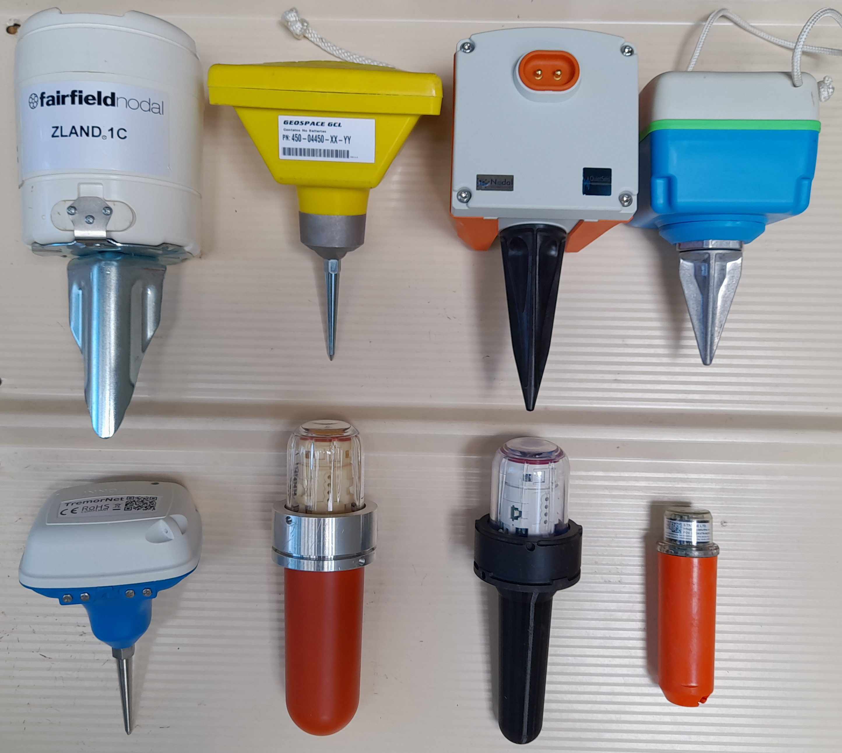
Figure 1: A selection of land Nodal systems. Image courtesy of Tim Dean, BHP
Pushing technology to its upper limits to determine true efficiency gains
There are a lot of variables to consider when designing and planning a seismic acquisition project. It’s obvious that there will be some cost differences between similar survey designs depending on the location of the survey and other factors. As we look at comparisons of different recording instrumentation we will normalise on fixed geometries and trace densities as well as assuming single point sources and receivers.
In the following discussion, we will look at operating costs per square kilometre and exclude known cost variations such as mobilisation and demobilisation.
The objective? To evaluate how the efficiency of the recording system technology impacts the overall cost, image quality, and HSE profile for a land seismic project.
A common approach when comparing technologies is to stress test each option by examining end-member scenarios that push each technology to its upper limits. These limits are related to combinations of variables such as:
- Number of traces collected per unit area
- Number of traces collected per unit time
- Cost per channel
- Time, equipment, and personnel required to deploy the receivers
- Time, equipment, and personnel required to pick up, download, recharge and re-deploy the receivers as the spreads move with the shot locations
Let’s think big and look beyond today’s conventional parameters. We will look at what it would take to collect a 3000 square kilometer survey that exceeds 1 billion traces per square kilometer. This trace density well exceeds today’s normal parameters but is not totally unheard of. Trace densities of this magnitude are indicative of the direction the industry is headed. The question is, will this level of trace density be increasingly viable as the efficiency of the recording system improves?
Imagine a 3000 km2 survey with 25 m shot and receiver line spacing orthogonal to each other with 6.25 m spacing along the lines in each direction, a typical size of survey we see some clients shooting in dathe MENA region.
Looking at the “not to scale” diagram below, if the project is 25 km in the N-S direction it would be 120 km in the E-W direction to generate the 3000 km2.
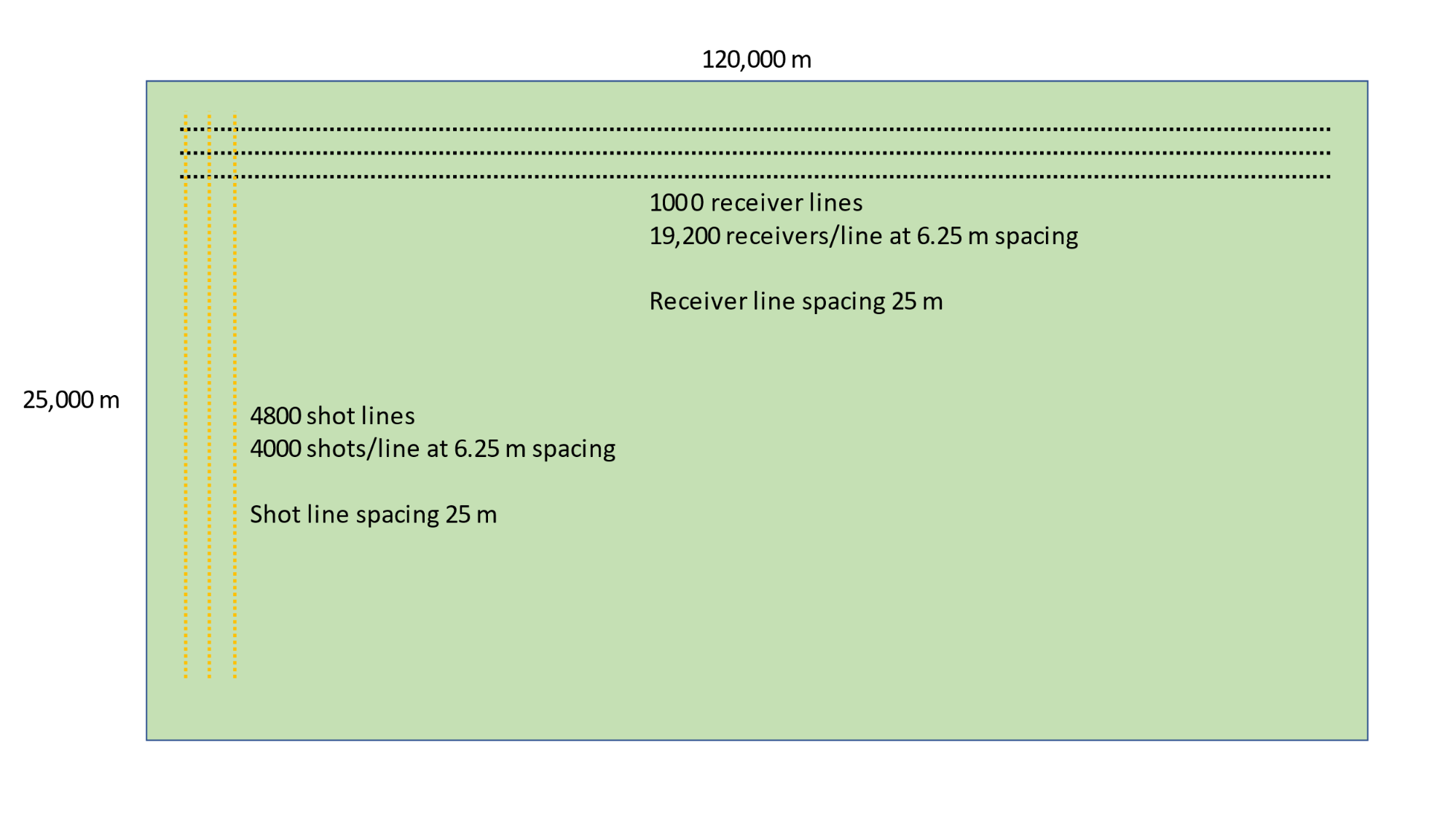
If the receiver lines run E-W and they are separated by 25m, that would yield 1000 receiver lines. Similarly, if the shot lines are separated by 25m there would be 4800 shot lines.
Next, if the shot and receiver spacings are both 6.25m that would yield
- 25000/6.25 = 4000 shots per line, and
- 120000/6.25 = 19,200 receivers per line
Next, if there are 4000 shots on each of 4800 shot lines, that is a total of 19,200,000 shots.
Similarly, if there are 19,200 receivers on each of 1000 receiver lines, that is a total of 19,200,000 receivers.
If the live spread for a shot is defined to be a maximum offset of 3000 m in each direction, there would be
- 3000/6.25*2 = 960 receivers on each of
- 3000/25*2 = 240 lines.
This yields a live receiver spread of 960 * 240 = 230,400 traces per shot.
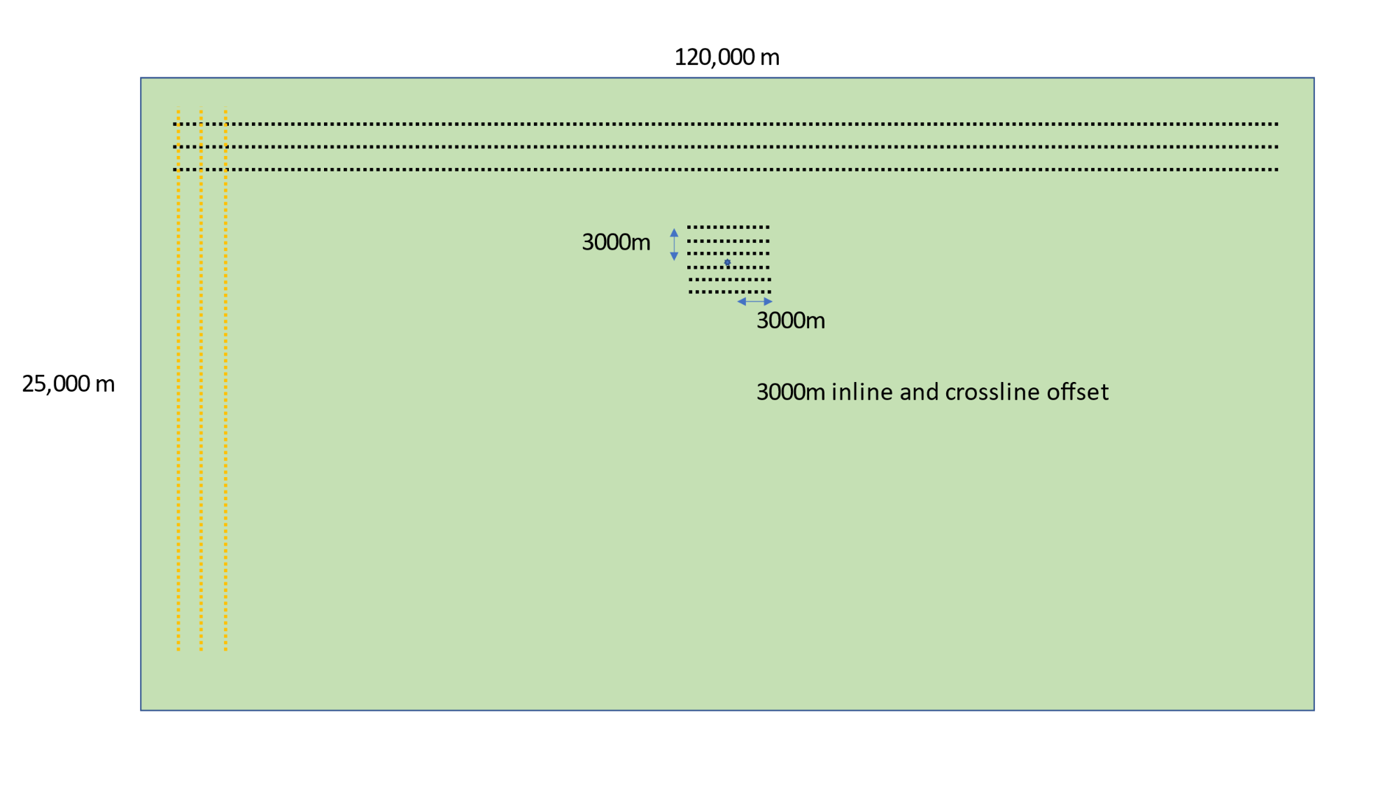
This super-dense scenario yields over 1 billion traces per km2.
Ourabah et al. (2021) discuss trace densities in the 100’s of millions of traces per km2 becoming the norm in open desert environments and present a case where super-dense surveys will be a viable option when efficient, fast-moving source technologies are combined with nimble autonomous receivers. An example of this combination has been observed in desert environments (Nehaid et al., 2019) and more recently for CCUS applications in Canada where a 256 million tr/km2 survey was acquired in 2021.
Let that sink in for a little while…
Final thoughts...
Don’t get trapped in the box of conventional thinking and technology. Look forward to solutions that will solve the problem and collect the optimum amount of data required to generate the subsurface image that tells you everything you need to know.