Geothermal energy accounts for less than 1% of today’s global renewable capacity despite its enormous potential as a carbon-free, continuous source of heat and electricity (IRENA, 2023). Recent global conflicts, characterised by high and fluctuating oil and gas prices, have exposed the limitations of the current renewable energy market, where weather-dependent green energy sources must coexist with fossil fuels for heating and for stabilisation of the electricity grid. This is a renewed opportunity for geothermal energy to become an important strategic solution to diversify and localise heat and energy production. Geothermal energy can provide the missing piece in the puzzle for a continuous, carbon-neutral energy supply and is unique in the renewable energy ecosystem in that it can provide electricity, heat, and value-added mineral extraction, independent of weather and global geo-political conflicts.
So, what is holding back the development of this free and abundant resource right beneath our feet? At the exploitation end, geothermal installations are efficient, scalable, and have low running costs. However, unlike other renewable energy sources, the early phases of exploration for geothermal energy can face comparatively high risk, longer project development timelines, and require considerable upfront capital expenditure (IRENA, 2023). While we see growing support from governments to mitigate costs and ease the burden of over-regulation and insurance costs (European Parliament, 2023) drilling remains the most capital-intensive aspect of geothermal projects and represents around 30-50% of overall costs (Dumas et al., 2013). This underscores the importance of thorough investigation of geothermal target areas to guide decision-making for well locations and to maximise well output. Successful exploration and characterisation of geothermal resources require accurate knowledge of the local subsurface geology (Ireland, 2023). The 2023 European Parliament’s report on geothermal energy states that “one of the most important challenges for geothermal is the lack of sufficient geothermal resource mapping” and calls for a unified effort to increase access to subsurface data in view to creating an EU-wide “atlas of geothermal potential” (European Parliament, 2023).
Seismic reflection surveys use sound waves to create an image of the subsurface structure of an area. These non-invasive methods are the backbone for exploration of gas and hydrocarbon reservoirs and mineral deposits (Maćkowski et al, 2019). Seismic data can be used to identify potential indicators of permeability and fluids, by detecting features such as sub-surface horizons, faults, fractures, and clay caps (Trainor-Guitton, 2020). Seismic waves produced by external sources (such as vibroseis trucks) travel through the earth and are partially reflected off geological features. This reflection data is captured by specialised sensors (receivers) and processed to create detailed images of the subsurface. The quality of seismic subsurface imaging has been progressively improving throughout the history of seismic exploration. While advances in data processing, survey designs, and acquisition methods have been important, it is clear that data quality improves greatly when the number of measurements (source/receiver pairs) per acquisition surface area or “trace density” increases (Ourabah et al, 2021) [Fig 1].
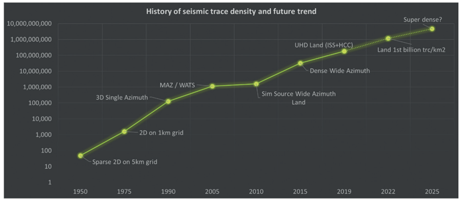
Figure 1. The increase of the number of traces per km2 since the beginning of seismic acquisition. Ourabah, 2021
These same seismic reflection techniques can be adapted to investigate geothermal areas even in complex geology and vapor dominated fields (Crosby and Calman, 1996). Parameters such as depth to top surface of the reservoir, its thickness, and volumetrics, can be interpreted from seismic data. The geometry of geothermal reservoirs and the positioning of faults help estimate water temperature and predict migration pathways for geothermal water (Maćkowski et al, 2019). Borrowing and adapting this technology from the oil and gas industry allows geothermal energy developers to reduce risks and quantify the energy yield (Ourabah et al, 2021). Until very recently, the inhibitive costs of high-resolution 3D seismic surveys put limits on its application to geothermal exploration, and legacy data was often used instead of new surveys tailored specifically for the geothermal target area (Ireland et al, 2023). Relying on legacy data or regional geological surveys instead of new, high-density seismic surveys has limited benefits for reducing risk in geothermal exploration. High trace-density seismic acquisitions have been shown to improve resolution and provide better signal-to-noise ratios, creating clearer final images (Ourabah et al., 2014). (Fig. 2)
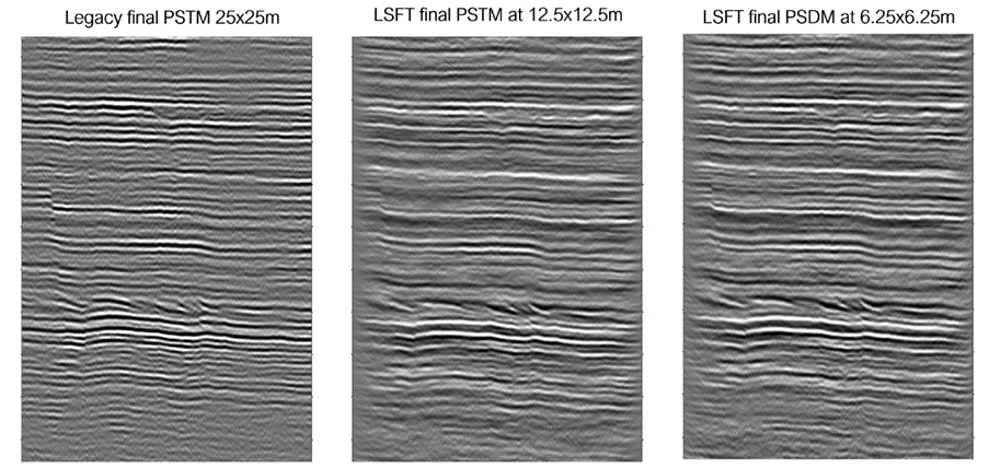
Figure 2. Large-scale field trial processing results compared to legacy data. Ourabah, 2021
The driving push in the oil and gas industry towards an ever-increasing density of surveys has led to the introduction of simultaneous source technology and single-point receivers. This technology has revolutionised the adaptability of seismic surveying in other industries, such as geothermal, not only because of the increase in survey density but also because of the collateral benefit of smaller, more nimble equipment keeping projects more financially viable and better suited to exploration in urban environments (Ourabah et al, 2021).
Traditionally, seismic land surveys were carried out using cumbersome and expensive geophone arrays which are connected by complicated systems of cables and auxiliary units to bulky central recording systems. They require heavy, costly manpower for deployment which reduces the possibility for large numbers of arrays to be deployed and therefore limits the density of surveys.
Even early on, researchers recognized the need to be able to acquire seismic data without the impediment of cabled systems, which often incur problems such as non-productive time related to power cuts and cable damage etc. (Dean and Sweeney, 2019). Seismic “node” technology developed in demand for higher density surveys and more agile equipment. Independent, single point receivers, distributed on a much denser grid are the natural successors to geophone arrays, allowing for real improvements in the density of surveys and streamlining of the survey process. They are proving to revolutionise seismic acquisition by introducing lightweight, cableless, autonomous systems enabling faster, denser, and more cost-efficient seismic land surveys. (https://geoexpro.com/nimble-nodes/)
The development of lightweight autonomous nodes has a particular importance for geothermal exploration, where the location for potential drill sites is almost always in close proximity to end users and therefore often situated in urban, industrial or agricultural areas. Cabled systems are highly impractical in this context and present constraints for survey planning and permitting in addition to being bulky and fragile (Ourabah et al, 2021). Small, autonomous seismic receivers enable surveys to be easily conducted in all types of terrain with minimal impact to local populations or the environment.
For nodal technology to significantly improve the speed and simplicity (and therefore cost and density) of a seismic survey it is crucial for the node to be fully autonomous, lightweight, and agile. Early nodal systems required radio transmitters, external batteries, and plug-in sensors which increase the bulk and weight of the units and therefore increase deployment time, impact on the environment, and issues with health and safety. The bulky, expensive nodes with poor battery life and hefty price tags, which are still on the market, do not offer vast improvements on geophone arrays.
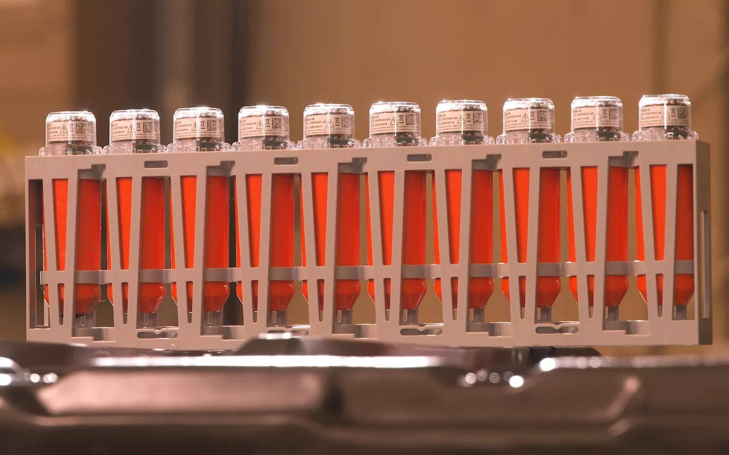
The smallest node on the market today is STRYDE’s “nimble” node. Measuring just 13 x 4 cm and weighing in at only 150 g, it is the lightest autonomous node on the market by at least 75% (Fig. 3)
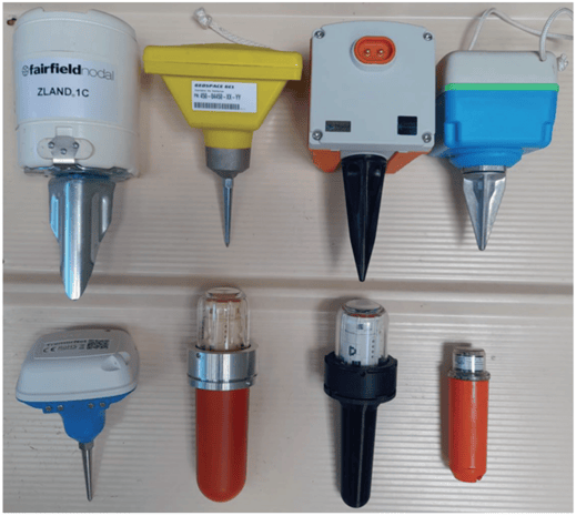
Figure 3: Selection of land nodal systems on the market. STRYDE’s node can be found on the bottom right. Image courtesy of Tim Dean, BHP.
By using optical downloading and inductive charging STRYDE Nodes™ avoid the need for external connectors and battery systems. STRYDE’s Node™ has been successfully used across a range of projects from oil and gas to carbon capture and geothermal and even archeological investigations (Ourabah et al., 2021). The diversity of projects points to the success of the STRYDE Node™ as a low-cost, cutting-edge technology that provides quality, high-density seismic surveys, whether the scope is for a vast arid location spanning 100s of km2 or a dense urban setting with sensitive environmental and social considerations.
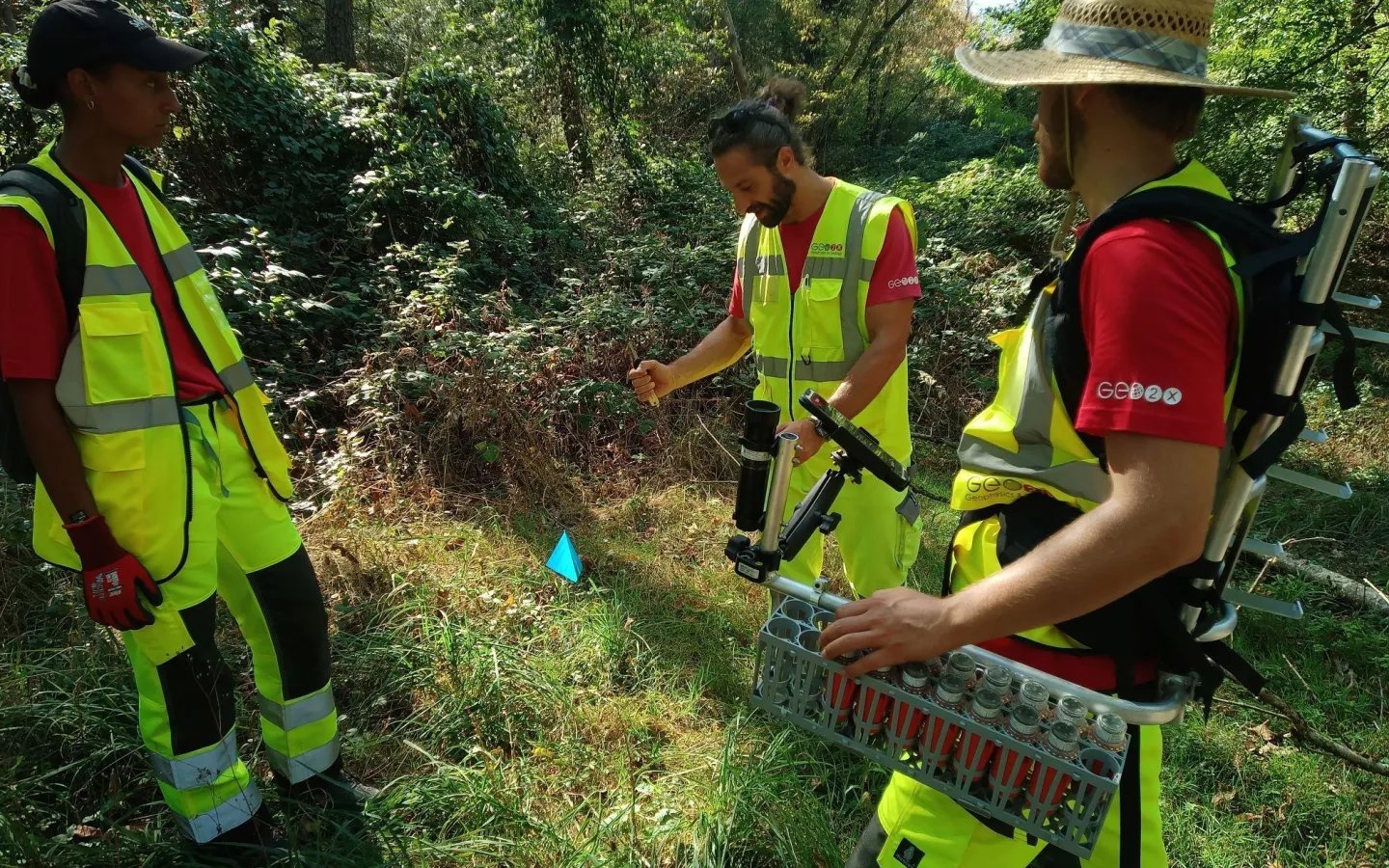
STRYDE Nodes™ have been specifically designed to be efficiently deployed on foot. Up to 90 nodes can be carried by a single person, resulting in significantly shorter deployment and retrieval times, easier access to complicated locations, and minimal impact to the local environment. The nodes are carried in ergonomically designed backpacks and can be reconfigured in the field, avoiding the need for heavy vehicles or specialist deployment personnel. This has a direct effect in reducing the cost of projects through simplification of deployment, as well as reducing the environmental impact of the surveys, thereby avoiding additional environmental permitting or community objections.
STRYDE’s nodal technology has recently been showcased on a project with Swiss Geo Energy in Eclépens, Switzerland to carry out the world’s densest 3D nodal survey for geothermal energy. To collect the data necessary for a detailed map of the subsurface area 21,000 STRYDE Nodes™ were deployed across 100 km2 of urban and agricultural terrain. The active source surveying took just 11 nights to complete and resulted in almost 100 terabytes of recorded data describing a volume of approximately 400 km3 (www.swissgeoenergy.com). An equivalent survey using cabled systems would have taken much longer from start to finish and would have been extremely complicated to carry out in such dense urban areas. Claudio Strobbia, the CEO of Realtimeseismic, states that we will see an “increase in this type of activity, as 3D seismic is the only geophysical technology that can provide enough accuracy to properly develop geothermal resources”.
Only through removing the roadblocks of the early planning and development stages of geothermal projects can we envision geothermal energy reaching its true potential. Technological advancements developed for the oil and gas industry, such as the STRYDE nimble node, could be the key to encouraging the investment needed to drive geothermal expansion.
Discover more about STRYDE here.
FIGURES
Fig. 1. The increase of the number of traces per km2 since the beginning of seismic acquisition. Ourabah, 2021
Fig. 2. Large-scale field trial processing results compared to legacy data. Ourabah, 2021
Fig. 3. Selection of land nodal systems on the market. Image courtesy of Tim Dean, BHP.
REFERENCES
Crosby D, and Calman I, (1996) Seismic Techniques in Geothermal Areas. 18th NZ Geothermal Workshop. Proceedings
Dean T. and Sweeney D. (2019) Recent advances in nodal land seismic acquisition systems. AEGC 2019: From Data to Discovery – Perth Australia
Dumas P., Antics M., and Ungemach P. (2013) http://www.geoelec.eu/wp-content/uploads/2011/09/D-3.3-GEOELEC-report-on-drilling.pdf
European parliament (2023), Report on Geothermal Energy 2023/2111(INI) https://www.europarl.europa.eu/doceo/document/A-9-2023-0432_EN.html#_section2
Ireland M., Dunham C., Gluyas J. (2023) Seismic for Geothermal. Geoscientist. https://geoscientist.online/sections/unearthed/seismic-for-geothermal/
IRENA and IGA (2023), Global geothermal market and technology assessment, International Renewable Energy Agency, Abu Dhabi; International Geothermal Association, The Hague
Maćkowski T., Sowiżdżal A., and Wachowcz-Pyzik A. (2019) Seismic Methods in Geothermal Water Resource Exploration: Case study from the Lodz Trough, Central Part of Poland, Geofluids https://doi.org/10.1155/2019/3052806
Ourabah A., Popham M., Einchcomb C. (2021), Game-changing nodes enable high-density seismic for any industry, First Break, Volume 39, 81-88
Ourabah A., Grimshaw M., Keggin J., Kowalczyk-Kedzierska M., Stone J., Murray E., Cooper S., & Shaw L. (2014) Aquiring and Imaging Ultra High Density Land Seismic Data – Practical challenges and the impact of spatial sampling. 76th Conference & Exhibition, EAGE
Trainor-Guitton W., The value of geophysical data for geothermal exploration: Examples from empirical, field, and synthetic data, The Leading Edge, Vol. 39, Iss 12, 2020.
Case Studies
Geothermal exploration enabled by STRYDE
A dense 3D nodal seismic survey for geothermal exploration in Switzerland
 A case study on 3D seismic survey where STRYDE seismic sensors were deployed in the countryside near Lausanne for geothermal exploration.
Acquiring high-resolution seismic data for geothermal exploration in an urban environment
 Discover how the world's smallest seismic acquisition technology was used for geothermal exploration within a challenging and restrictive urban environment.